Where should I start on the state of the B&B facilities? I was so angry that I felt I had been ripped off, and so disappointed that I didn’t get the little bit of comfort that I wanted after such a hard day yesterday. The manager wasn’t there and I left without breakfast (that’s how bad it was). I revisited tescos to make myself a baguette instead. I was fuming for a couple of hours.
looking back across Langstone Harbour towards the South of Hayling Island (at low tide)I followed the Hayling Billy Line (a WW2 train track turned into a cycle path) straight up the West side of the island. It was shaping up to be another hot and sunny day.
the view towards Portsmouth from the Langstone BridgeThe tide was out and wherever I looked there were mud flats, channels and lots of shoreline. Chichester Harbour is huge and has 2 ‘fingers’ of land poking into it (Hayling Island and Thorney Island), as well as lots of other tiny islands.
crossing the Langstone BridgeI crossed Langstone Bridge, leaving Hayling Island and following the Wayfarer’s Walk along the shoreline from Havant to Emsworth.
pretty Langstone, just across the bridgeThe small town of Emsworth used to have a big oyster trade, selling 100,000 a week to London. The harbour would have been full of Oyster Smacks, the biggest being the 110 ft long Echo. This Emsworth boat was said to be the largest sailing fishing vessel ever built in England.
walking around Emsworth’s Fisherman’s WalkIn Emsworth I had a quick cafe stop to get the coffee that I had missed by not having breakfast. I was still angry, and tired, and rehearsing how I was going to get my money back.
looking across Chichester Harbour at the East side of Hayling Island (still low tide)More footpath confusion as I tried to find my way around Emsworth Marina, crossing the River Ems and into West Sussex. It did little to improve my mood! Perhaps a nice walk around Thorney Island would help.
walking the sea wall towards Thorney Island, just across the Great DeepAlthough now connected to the mainland thanks to seawalls, the Great Deep channel did once cut the Thorney Island off. It is now cut off by big, locked gates as it is MOD land (it used to be an RAF station until 1976). The Sussex Border Path tracks around the edge of Thorney Island for 6 miles and access is granted by buzzing the Guard Room, and the guards remotely unlock the gate. No problem.
another view of Hayling Island across Chichester HarbourIt was a nice walk and there were a few oystercatchers and boats for me to look at across the harbour. It took me 2 hours to get around to the east access gate, complete with handwritten sign indicating the gate was broken. That couldn’t be right. I pressed the buzzer and was told the gate was broken, as per the sign, and I would have to go back the way I had come. This was red rag to a bull. The steam coming out of my ears was probably visible for miles as I blew my stack. Why wasn’t there a sign on the other gate? Why hadn’t they told me this gate was broken when they let me through the other gate? What was wrong with the gate? Were they really telling me I had another 6 mile, 2 hour walk back around Thorney Island to get back to where I started? Who was their commanding Officer? I wanted him to come and explain this to me ASAP and I wanted a car to drive me back around (not possible I know). I had almost reached the point of resuming my military rank and they had put me on hold while they fetched someone of superior rank who would come and see me. Suddenly I heard a buzzer sound and so pushed the gate. It opened. Not so broken after all! Had I not been so stressed and so tired with so far still to go I would have taken them to task on this as it was shocking behaviour.
this time looking across Chichester Harbour towards West ItchenorI carried on skirting around Chichester Harbour. I decided not to bother walking around the next ‘finger’ of land at Chidham and just followed the A259 straight along to the final ‘finger’ at Bosham. This one had a ferry across the Chichester Channel to West Itchenor so I avoided having to walk back inland to Chichester and around.
the tide coming into Chichester Harbour; the view towards the harbour entrance from NutbourneBosham was a very well-kept and smart little town. The houses looked lovely. I stopped at a cafe for some lunch and a break from the hot sun. It was also time to phone the West Town Inn and ask for a refund. I was calm and reasoned and Marcus was very nice about it, apologised and offered to refund me in full (even though I was prepared to pay half what I was charged as a fair fee for the service received). A small win.
BoshamI caught the small, seasonal ferry and walked through West Itchenor.
the ferry across the Chichester Channel to West ItchenorI was headed for the Witterings and there were plenty of campsites so I thought I’d be fine. Mistake. The first 2 I phoned didn’t have room, not even for a hiker with a small tent – they didn’t even think about it, just a flat ‘no’. The 3rd campsite wanted £25 and the 4th, £16. By now my search was getting too far away so I resolved that I just had to pay the £16 and acknowledge that this section of South Coast is just very expensive.
It was a longer walk to the campsite than I wanted and I headed straight there along the roads. Fortunately the site was quite nice and it was an easy walk along a track to East Witteribg for some dinner. After a pretty stressful day I was pleased to find a nice Italian restaurant with wifi, a plug socket and wine.
On reflection, I had managed to get winning outcomes to my frustrations today. I had shouted at the military and reasoned with the civilians. I am adding adaptable and tenacious to my CV.
I made it into Sussex; unfortunately it only has a border path and not a coastal path!
I was up and away in time to catch the first pink ferry across the River Hamble at 9 am. I was too early for cafes so made a brief stop at co-op for a bit of breakfast.
looking back across the river at Hamble, just visible through all the boats!Hamble was chocolate-box pretty and I saw lots of expensive cars in driveways. I didn’t know that the RAF has its yacht club base here; if I had I might have joined!
how to find the ferry amongst so many boats – paint it pink!The pink ferry navigated its way through the hundreds of moored boats and dropped me at Warsash. I walked up to the main street and found somewhere to get a coffee. Chatting to the lady in there I discovered that Hamble was considered the more pretentious, boaty town than Warsash, but these Hamble Valley neighbours do get on. Warsash has a world-renowned maritime academy.
Warsash Clock TowerThe sun was shining as I made my way past Warsash’s old strawberry fields (strawberries are no longer grown here), around the edge of the River Hamble and back onto the banks of Southampton Water.
looking back towards Warsash, along the edge of the River HambleI was following The Solent Way, which seems to be Hampshire’s coastal path. Unfortunately it is very badly signed and I had to backtrack a few times today as it was at times difficult to discern the route on the map and there were very few signs to help me out.
the shingle alongside Southampton WaterThere was a lot of open ground, a mixture of grass, mud and shingle, along the edge of Southampton Water. The path ended up on a small cliff top and there was significant erosion that had closed a section of the Chilling Coast. What a shame no one bothered to put any diversion signs up. Fortunately some holiday home owners gave me directions.
looking back at SouthamptonI reached Lee-on-the-Solent and had a promenade to walk along, past the old Naval airfield where I once spent a University Air Squadron summer camp.
Lee-on-Solent promenadeI had reached Gosport and I passed The Diving Museum, next to Browndown Army Camp and kept going, around Stokes Bay, to Gilkicker Point.
Neufeldt and Kuhnke’s 1939 design atmospheric diving suit; unfortunately the joints leaked!The 1860 Grade II* listed Palmerston Fort at Gilkicker Point was boarded up and fenced off; not that this seemed to bother the kids who were scaling its roof. It did look in a sorry state and certainly no longer capable of defending the entrance to Portsmouth Harbour.
the rather dilapidated Fort GilkickerTo get to the narrow harbour entrance I had to pass HMP Haslar, now an immigration detention centre, and the old Haslar Military Hospital. The hospital had been turned into luxury apartments.
passing the old Royal Hospital HaslarPortsmouth waterfront looked impressive, particularly Spinnaker Tower.
looking across the water from Gosport to PortsmouthI also picked out the BAR team shed but no sign of the America’s Cup yacht.
the BAR headquarters and boat shedThere was an interesting contrast of the old Naval warships berthed alongside the new.
an old Naval Warship……berthed alongside a new oneI walked straight onto the Gosport Ferry, which reminded me a bit of the Mersey Ferry; it was a big boat and a slick operation. They don’t sell single tickets so I need to go back sometime.
The Spinnaker TowerI have been to Portsmouth many times, but never to the old part. Once out of Gunwharf Quays, the busy, updated shopping precinct, I found myself in Old Portsmouth. Just like Plymouth, there were lots of memorials and commemorations of various sailings from the historic docks. I could have spent a day here looking around.
memorials to the Falklands War and the convict ships that sailed to found modern Australiathe Royal Navy War Memorial for all those from Portsmouth’s shipsInstead I walked along the Millenium promenade, past Southsea Common and all of its memorials (including the main Naval one that is the equivalent of the one in Plymouth), to Southsea Castle. This castle complements Gilkicker Fort on the other side of the harbour entrance.
Southsea CastleThe path followed the long beach, past South Parade Pier, past the Royal Marines Museum, and all the way to the entrance to Langstone Harbour.
Portsmouth’s beach and promenadethe entrance to the Royal Marines’ MuseumI had decided not to walk up the the East side of Portsea Island (the island that Portsmouth inhabits) but instead to get the ferry across the mouth of Langstone Harbour to Hayling Island. Both Portsea Island and Hayling Island are a bit bell-shaped so they present a long south coast to the sea and then the harbours of Portsmouth and Langstone open up considerably after a narrow entrance.
Spitbank Fort in the SolentOn my way to the Hayling Ferry (which only re-opened a few days ago after a couple of years with no operator) I passed a campsite. I was tired and there was a bar so I changed my mind and went in to see if I could stay. After waiting 15 minutes to speak to someone at reception I was told there was room for me…at a cost of £30. I left. It was another one of those holiday parks.
I had to rush to catch the ferry after that as they only ran every 40 minutes and I didn’t want to miss the 5.40 pm crossing. I just about made it and walked straight on…and then straight off the other side. I was so preoccupied with wondering where I was going to stay that I didn’t notice I hadn’t paid. I asked some cyclists and they said that, just like the Gosport Ferry, this one only sold return tickets so the operators must have assumed I was on my return journey. No wonder they went out of business for a while!
It was almost 6 pm and I had nowhere to stay. I was very tired and wanted some luxury so I phoned a guest house in West Town and splashed out. It seemed every type of accommodation, from campsites upwards, had suddenly jumped up in price. As I was about to find out, that did not reflect a jump in quality or standards.
The bed was clean and there was a Tesco nearby so I was alright for the night. However; there were people screaming at one another in the street from midnight for an hour and the accommodation was awful: window blinds that wouldn’t open and fell down, dirty floor, no hand soap, and the list went on. I was unhappy at being ripped off and more would follow in the morning.
A disappointing end to a long and interesting day.
Despite an interrupted sleep I was up early. It had rained! Only for about half an hour at 5am. The skies were grey with no sign of sun.
looking at Cowes across the River MedinaI headed for the chainlink ferry across the River Medina to Cowes. Although only separated by a river, and sharing a name, East Cowes and Cowes are quite different. East Cowes is small and known for its shipbuilding. There are still big sheds facing onto the river. The most famous is the Columbine Shed, which belonged to the Saunders-Roe firm who built seaplanes (beginning in 1913) and then hovercraft. The world’s first hovercraft was built and launched from here in 1959. Since the Queen’s Jubilee in 1977 the Columbine Shed has been recognised by its Union Jack door.
The Columbine Shed in East CowesThe chainlink ferry has been running since 1859 and before that there was a rowing boat and a horse-winched barge. It cost me £1 for a return ticket, which saves a trip into Newport and out again. What a bargain.
the chainlink ferry crossing the River MedinaCowes is known as the home of world yachting and the birthplace of the America’s Cup. At 8am it was pretty quiet, which was understandable after last night’s party. Sailing types were appearing though and could be distinguished by their slightly dishevelled (but not too dishevelled) appearance, Musto clothing and enormous kit bags. I did not look the part. Never one to let that deter me I headed straight for the marina.
one of the Cowes Marinas during Cowes Week…so many yachts!Around the moored yachts sailors were scurrying around like little ants. I stood on a jetty and watched. From the variety of accents and the markings on the boats (e.g. a big silver fern) it was obvious that this was an international event.
even the RAF had a yacht racing at Cowes WeekI had company and we started chatting. This man was sailing on a very nice yacht (worth £80k) that his (very rich) friend owned. He filled me in on what happens at Cowes Week. It did sound like a lot of fun. In return I told him about my trip and he thought it sounded cool so we were even.
the race start…avoid the tanker!Next I wandered through the town. More sailors. Everywhere. All getting coffee. I bought a pain au chocolat from the bakery and carried on. I wanted to see the Royal Yacht Squadron (RYS): the home of yachting. I wondered if I might be able to blag my way in for a spot of breakfast, but that was never going to happen. One has to be a bonafide member of this place.
The Royal Yacht SquadronI discovered that the RYS runs Cowes Week. In front of the exclusive clubhouse was a flagpole (able to hoist 9 flags) and a row of cannons. Katy was prepping the cannons and then Paul arrived in ful rig (complete with hat). They were both employed by the RYS. I chatted to the two of them and learnt lots about how the racing works. Essentially, flags are hoisted to signify which class of boat is due to start, then the small cannons signify prep and the big cannon the start. However, while some are prepping, some are starting so it all gets complicated.
Peter outside the RYS, operating the flags and cannons to start (and finish) the racesThe first race started around 10am and by then there looked to be scores of different sized yachts milling about near the start line. To add another complication, there were also ferries, container ships, sea kayakers and moored yachts. This was chaos. Fun though.
prepare to fire…I wandered back through town and stopped for a coffee and bacon sandwich. I had had enough of the “sailing set” so caught the chainlink ferry back to East Cowes and returned to the campsite to pack up. Within an hour I was on the ferry to Southampton.
…fire!I had a great view of all the races as we crossed the Solent and entered Southampton Water. The wind had picked up and some of the boats looked like they were flying.
on the ferry, aiming at the racing yachts…how many can we take out?Welcome to Southampton! (I think this sign might indicate that more people arrive by boat than car)We docked in Southampton and I walked along the edge of the old town and across the bridge over the River Itchen.
one of 4 docked cruiselinersGod’s House Tower (built 15th Century to protect Mediaeval Southampton from attack)I walked all along the Weston Shore, past Netley Abbey and the Royal Victoria Military Hospital, both of which were landmarks from the ferry.
the (derelict) Royal Victoria Military HospitalAside from the wind, it was a lovely walk along the shoreline to Hamble-le-Rice. There were lots of anglers out and plenty of people enjoying the parkland.
looking bacl along the Weston Shore towards SouthamptonThe sun had come out and I walked up the River Hamble to my campsite.
WW2 anti-aircraft gun on the beach at Hamble-le-RiceI was relieved to find the campsite was next to the Mercury Yacht Harbour, which had a bar and restaurant overlooking the marina and the river. Perfect.
the view from the restaurant overlooking the Mercury Yacht Marina on the River Hamble
Lymington, Hampshire to Freshwater Bay, Isle of Wight
12 miles (+ ferry)
Totland YHA
I caught the train from Reading back to Lymington Town and then crossed the Lymington River, arriving at the ferry terminal before midday. This walk has definitely had a big impact on my need to plan and book. despite 6 days off I had not booked a thing and, best of all, was not stressed about it. That’s 18 years of conditioning I’ve undone in the last year!
back at LymingtonI was able to board the next ferry and by 1pm I was crossing the River Yar and walking out of Yarmouth.
the ferry at YarmouthI entered Fort Victoria Country Park and followed the track with the carved animals towards Fort Albert. These forts are opposite Hurst Castle and, together, all 3 protect the entrance to The Solent.
looking across the Solent to Hurst Castle and lighthouseAt Colwell Bay I stopped in the shade to eat my sandwiches and cake (thanks mum).
Colwell BayThe coast path connecting Colwell and Totland Bays only reopened last year after work to circumvent a landslide that happened in 2012.
oops, there’s been a landslidewhat’s left of Totland PierFrom Totland I headed over Headon Warren, the South side covered in beautiful purple heather.
purple heather on Headon Warren, looking across Alum Bay to The NeedlesI could see The Needles and Alum Bay with its chairlift down the cliff. This is where mum’s testube full of layers of different-coloured sand came from. I walked straight past as I’ve been on it before and I didn’t want to negotiate the pleasure park.
the Alum Bay chairliftthe lovely colours of Alum Bay cliffI climbed the cliff heading out to The Needles’ Batteries. There were some great views out towards Old Harry. The chalk cliffs were beautiful and white. The Needles looked thin and worn away!
The NeedlesBetween 1956 and 1971 there was a rocket engine test site here. Black Knight and Black Arrow rockets were held down in gantries and their engines fired up. If they passed they were sent Down Under for test launching.
the rocket engine test siteI turned East and headed up Tennyson Down to Tennyson’s Monument. Erected in 1897 it dominates the skyline. From the top of the Down I could just about see all the way to St Catherine’s Point and the flashing lighthouse.
Tennyson’s Monument atop Tennyson DownTennyson’s MonumentI dropped down into Freshwater Bay and then headed back to Totland, this time along the roads.
looking down on Freshwater BayThe Western tip of the Isle of Wight is an island in its own right as the River Yar runs all the way from Yarmouth to Freshwater Bay, bisecting the land.
the view along the Solent from Headon WarrenCompton Bay from Tennyson DownI got lucky and there was a spare bed in the Youth Hostel. I didn’t want to camp in the gale force wind that was blowing. I was able to get a cheap evening meal and access to rubbish wifi.
I had a lie-in at Kath’s, partly because she wanted to walk with me (she’s not an early riser) and partly because she promised bacon sandwiches. Unfortunately Geoff couldn’t make it so Suzy drove for the sandwiches before we were up and we all set off together sometime around 10am.
Suzy and Kath posing in front of the River StourFollowing Kath’s good advice we started with the Stour Valley Way, heading alongside Christchurch Harbour and out to Hengistbury Head. It was a grey day with dull light but I could still see for miles from the elevated position on top of the dunes covering Hengistbury Head.
the view back to Bournemouth from Hengistbury Headthe River Stour from Hengistbury Headthe two spits guarding the entrance to Christchurch HarbourThere were some lovely beach huts on the spit of land protecting Christchurch Harbour. We were able to get a ferry across to mouth of the harbour to Mudeford, Christchurch.
Me and Suzy on the Mudeford Ferry (note the lovely beach huts in the background – they cost a fortune)We stopped at The Noisy Lobster next to Avon Beach, Mudeford for coffee and cake.
lobster pots at the entrance to Christchurch HarbourBefore I knew it the afternoon was upon me and I’d hardly walked anywhere. It had been a lovely, relaxed morning though. I waved goodbye to Kath and Suzy and headed along Christchurch promenade, which was rather similar to Bournemouth’s. At some point I crossed into Hampshire.
Christchurch beachI asked a lifeguard if I could get all the way along the beach to Milford on Sea and he assured me I could, even though it was nearly high tide. Hmmm. Halfway along I passed the warning signs telling me cliff subsidence had made a section too dangerous to pass. I didn’t want to go back and there was no way up the high cliffs so I gingerly picked my way over the mud and boulders, following a route I could see had been travelled before. Fortunately I made it. If I had needed rescuing I was going to blame the lifeguard.
it doesn’t look that bad from here!The cliff erosion was quite stark and reminded me of Norfolk; the cliffs were composed of the same sort of sticky, clay/mud.
the high cliffs around Barton on SeaEither side of the landslip, however, there were plenty of people on the beach and lots of beach huts. Many of the ones at Milford on Sea had been damaged in the 2014 storms. more beach huts below the crumbling cliffsEventually I made it up to the clifftop and breathed a sigh of relief. The views were better from up here.
the view back towards Bournemouththe view onwards, towards Hurst BeachI had a great view of The Needles as I reached Milford on Sea. There were some nice houses facing the sea but it all had a depressed air about it; it might have been the grey day.
a man fishing off Hurst Beach; a great view of The NeedlesHurst Beach is a 2km spit of shingle, like a smaller version of Chesil Beach, that sticks out from Milford on Sea into the Solent. It forms a shifting barrier that protects the western approach to the Solent. I didn’t walk all the way along it to Hurst Castle and lighthouse at the end; that would have been tough going along the 300,000 cubic metres of shingle. I did learn that Hurst Castle was built in 1544 (another of Henry VIII’s forts) and that King Charles I was held prisoner there before his final journey to London.
looking along Hurst Beach, the Isle of Wight in the backgroundInstead I turned North East, folowing the Solent Way along the fringes of the New Forest National Park. I skirted around the huge saltmarsh and mudflats created in the shelter of Hurst Spit.
looking across Keyhaven Marshes to the Isle of WightAt Pennington Marshes I headed inland slightly to my campsite. I was tired and camping did not enthrall me. I knew I needed a break when I managed to lose my phone charger (fortunately someone picked it up and left it on a picnic table). I had been planning to head to the Isle of Wight tomorrow and head home at the end of the week but I decided to change my plans and catch a train home tomorrow. That decision lifted my mood considerably; I did need a break.
the Brownsea Island Ferry (Brownsea Island in the background)I convinced Andrea, Amelie and Ruby to join me on a trip to Brownsea Island, the home of Scouting. The 10 minute ferry went from Sandbanks and it was popular; we had to wait for the 2nd one. There were lots of Scouts in their uniforms.
approaching Brownsea IslandBrownsea Island is covered in trees and very pretty. It is owned by the National Trust and I thought it was quite expensive to visit. The return ferry trip cost the same as a going to the Isle of Wight, and then there were the landing fees. Still, it was much more tranquil than Sandbanks.
The Scout Commemoration StoneWe had a picnic on the grass and watched lots of peacocks roaming around, many approaching picnickers for titbits.
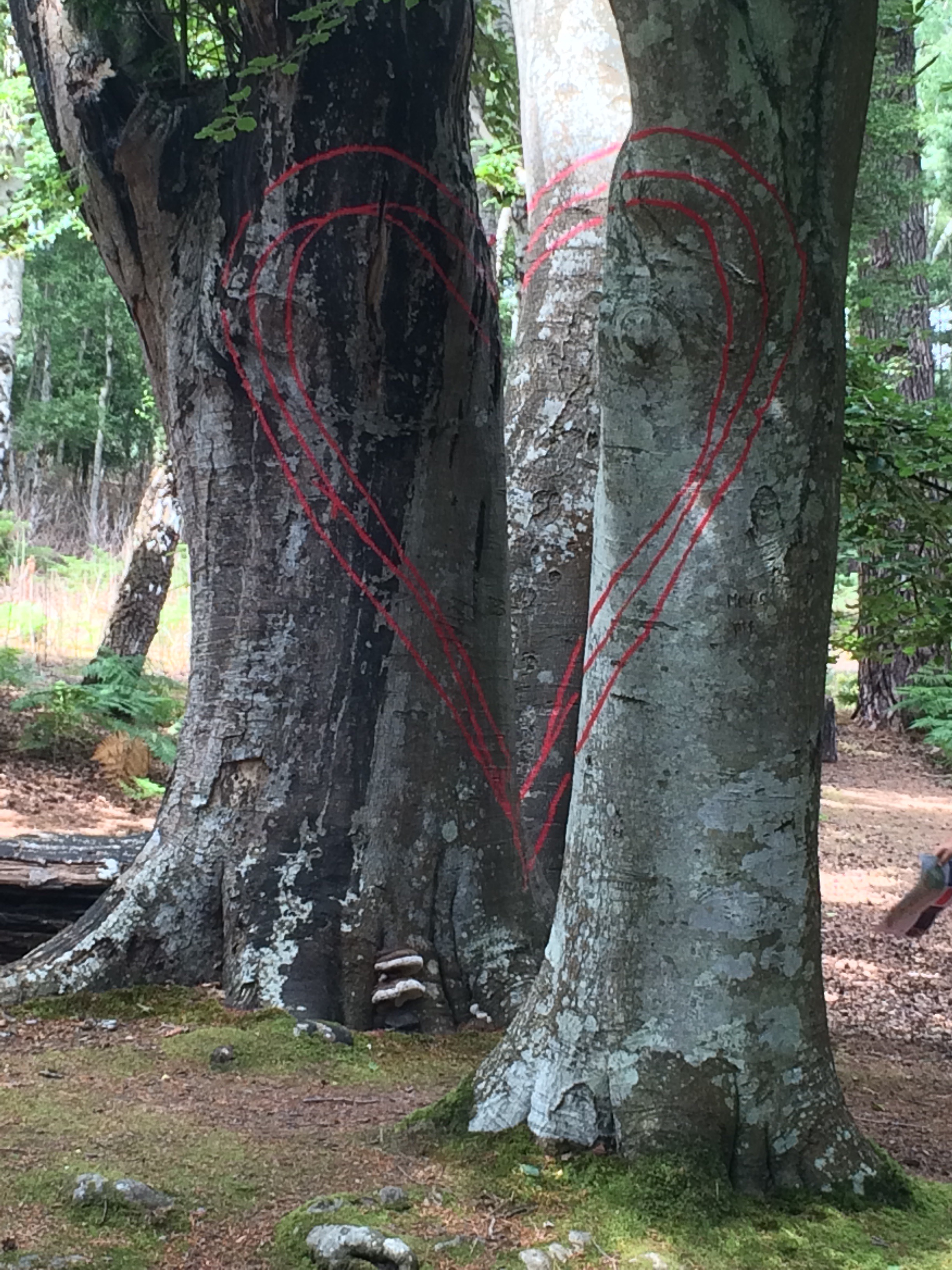
up close to a peahen and her peachickWe walked back to the jetty via some cool art work in the woods. Red lines had been painted on trees so that if you stood in the right spot the lines all matched up to make a heart. Very clever.
a red heart……and another……and anotherBack at Sandbanks we walked along the beach to the car park, where I collected my rucksack and we said goodbye. It had been a relaxing morning.
looking back along Sandbanks’ beach towards Brownsea IslandI carried on along the promenade that runs right through Bournemouth. There were plenty of people enjoying the sunshine, on the beach and sat outside the many, many beach huts that line the promenade.
it’s a long promenade around BournemouthI had fantastic views across Poole Bay, from Old Harry to the West to The Needles and the Isle of Wight to the East.
Is that the Isle of Wight?i think the volume of sand has increased further along the promenade!There was an RAF Hercules circling around the Bay for ages. Twice I saw it drop things into the water, including at least one boat. Must have been the SBS practising. Whatever, I was surprised by just how many people take binoculars to the beach!
a Hercules flying over Old HarryBehind the promenade, the cliffs are quite high and there are a couple of cliff lifts for those who don’t want to climb the zig zag pathways to the top. Naturally I caught a lift.
travelling up East Cliff LiftI made my way to Kath’s house, not far from the Stour Valley. Kath’s friend, Suzy, joined us for the evening and we all walked to The Pie House in Tuckton for pie and mash. Delicious.
looking back along Bournemouth seafrontlooking ahead to Hengistbury Head and the Isle of Wight
It was very windy during the night and I was glad that I was tucked behind a big hedge. It was a fairly dull start to the day but that didn’t last long and soon the sun was bright, the sky was blue and it was another scorcher. Unfortunately the wind died down so that made it feel hotter.
looking across The Fleet to Chesil BankIt was lovely walking through the Fleet Lagoon Nature Reserve, with great views of Chesil Bank. I was struck by the large numbers of butterflies, of several species; more than I had noticed elsewhere.
Chesil BankChesil Beach is one of the finest storm beaches in the world; formed over 6000 years ago by rising sea levels. It is 18 miles long, rises up to 15m high in places, and is made up of 100 million tonnes of pebbles. It is amazing to walk alongside (it would be energy-sapping to walk along it) and to see how it changes. The pebbles grow in size from pea-sized in the West to potato-sized in the East. Apparently, on a foggy day, local fishermen (and smugglers) can tell whereabouts they are on Chesil Beach just by the size of the stones.
Chesil Bank is quite big in placesI walked past a couple of Army camps on the edge of Weymouth and found out later that the town had been the main base for Anzac troops convalescing during WW1.
another view of The Fleet and Chesil BankAfter an exposed walk in the heat, with no refreshment stops, I made it to Wyke Regis and Ferrybridge, the tip of Weymouth. I was hungry.
Chesil Beach curving around to the Isle of PortlandI crossed the road heading across the tombolo to the Isle of Portland, that would be tomorrow’s walk. Instead I turned North East and walked along the edge of Portland Harbour towards Weymouth sea front.
a plaque on the housing estate is the only reminder this was once the site of a torpedo factoryRight at the tip was a housing estate built on the site of the demolished Whitehead’s Torpedo Factory. Torpedoes were built here, and tested in the harbour, between 1891 and 1969.
looking down one of the breakwaters that creates Portland HarbourPortland Harbour was a Victorian engineering project that took 23 years to complete by 1872. Back then it was one of the largest man-made harbours in the world and Europe’s finest deep-water port. Naturally it needed protecting and so 3 forts were built: one in Weymouth (Nothe Fort), one on Portland, and one on the Breakwater. These forts were part of the 74 Lord Palmerston forts built all along the South coast, from Milford Haven to Harwich, to protect us against the threat of a French invasion. (Every day more jigsaw pieces are added to the picture in my head.)
the view from Nothe Fort, protecting Portland HarbourI thought the harbour looked impressive. I stopped for an ice cream at Sandsfoot Castle, built under the orders of King Henry VIII to protect shipping in the ‘Portland Roads’. Thus confirming that Portland Harbour has been important for a long time.
Sandsfoot Castle ruinsI was still hungry. I saw a sign for a cafe at Nothe Castle (rhymes with clothe) and made a beeline. After some refreshment I took the opportunity to look around the fort and I’m glad I did. It had some excellent displays and was a great little museum. Being a fort, it was of course well placed to afford some of the best views. How lucky that the sky had turned so blue to make the views all the way from the Isle of Portland to the Isle of Purbeck even more spectacular. I stayed for a while to enjoy them.
inside Nothe Fortlooking at Weymouth from Nothe FortI like to catch a ferry and there was a rowing boat ferry across the River Wey from Nothe Fort Gardens to the old harbour. I hadn’t been ferried by a rowing boat since Suffolk! This one cost me £1.
my ferry across the River WeyThe summer holidays had started; Weymouth Beach was packed. There were people everywhere, many burning in the hot sun. The green sea looked cooling but I couldn’t face the crowds so I carried on walking along the promenade, dodging the tourists.
Weymouth BeachI was intrigued to see the Royal Navy holding a beach rugby tournament; a good way to draw in spectators.
Weymouth is known for its sand sculptures – apparently it’s the right kind of sand!King George III spent 14 summers in Weymouth, helping to establish it as a holiday destination from the late 18th Century. The town’s affection for the King was evident. I admired his bathing machine sat in the middle of a roundabout.
a bathing hut fit for a KingI had arranged to meet up with my next-door-neighbour, Grace, as she often works in Weymouth. So, once I reached Lodmoor Country Park, I turned around and walked back along the promenade to the harbour and the Ship Inn.
the beautiful white cliffs of White Nothe (and all along to Lulworth) visible from Weymouth Beachlooking back along Weymouth Beach to Nothe Fort and PortlandAfter a lovely catch-up with Grace (and the chance to rid myself of a few old maps) I was collected by Geoff and driven to his house in Dorchester. It was great to see Geoff and Kath, enjoy a BBQ, do my laundry and sleep in a bed.
Weymouth Harbourtypical Weymouth seafront houses, all decked in bunting
Holly dropped me back in Teignmouth early and I wandered around the town centre before getting on a train to Starcross. There wasn’t much to Teignmouth first thing in the morning and I had a pretty average coffee.
Starcross, right on the River ExeI had decided to get the train along the coast through Dawlish and Dawlish Warren as it looked more exciting than walking.
the train line from TeignmouthThe train went through a couple of tunnels bored through the cliff. I enjoyed a lovely view of the red cliffs, and then of the town of Dawlish and the entertainment centre that seemed to be Dawlish Warren.
looking back at Dawlish Warren sand spit across the River ExeI arrived at Starcross in time to catch the first ferry across the River Exe to Exmouth. I’m not sure what it is with ferrymen in South Devon but this pair waited until we were supposed to leave before departing the vessel (leaving the engine running) to make themselves a cup of tea in the ferry hut. Clearly arriving at work 10 minutes earlier (when the start time was 10 am) was too much.
well-manicured Exmouth, a shelter to watch the seaI walked along Exmouth’s sea front promenade, past the beach full of schoolchildren enjoying various water sports, and headed up onto the cliff at Orcombe.
lots of kids in the sea below Orcombe PointThe Geoneedle at Orcombe Point signifies the Western gateway to the Jurassic Coast World Heritage Site. To call the 95 miles of coast between Exmouth and Studland Bay the Jurassic Coast is a misnomer as the rocks tell the story of the Triassic, Jurassic and Cretaceous periods. The oldest rocks, a mere 250 million years old, are the ones at Orcombe Point; the story unfolds from West to East so I am heading in the right direction.
The Geoneedle (behind it Exmouth on the right and Dawlish on the left)The Triassic cliffs are deep red and the shingle beaches are covered in quartzite, round pebbles, marking the course of a huge river that once flowed through a vast desert. The river originated in Brittany and longshore drift causes the pebbles to continue to move East, from Budleigh Salterton to Chesil Beach and even as far as the Isle of Wight.
the amazing red cliffs on the way to Budleigh Salterton (“bleeding” into the sea)I passed the enormous holiday park full of static caravans above Sandy Bay and next to the rifle range at Straight Point.
looking back at Straight PointThe colour of the cliffs was incredible and made the sea look muddy at their base. The path curved up and down like a wave. Many of the cliff top paths seem to be given names and The Floors took me to Budleigh Salterton. I passed straight by the town along the sea front.
approaching Budleigh SaltertonTo cross the River Otter the path took me a kilometre inland to the first bridge and then back out again and over Otterhead.
the River Otterlooking back on Budleigh Salterton across the River OtterIt was a long, curvy walk up and down to Sidmouth. The standout sections were Ladram Bay and Peak Hill.
Ladram Bay, High Peak and SidmouthLadram Bay had some amazing rock formations that had been created by erosion.
Ladram Bay rock formationsIt was hot work climbing up Peak Hill (fortunately the path did not go to the top of High Peak just before it) but the view was incredible. I could see all the way back around Lyme Bay to Berry Head at Brixham.
looking back on High Peak and all the way back to Berry Head, from Peak HillI had really picked the pace up as I climbed Peak Hill and descended into Sidmouth so that I made the 3pm bus. I had to get a bus to Exeter and then the train to Teignmouth, where Holly collected me for my final night in a bed for a while.
approaching SidmouthThe Regency Town of Sidmouth looked like a great place to retire and I saw plenty of oldies playing croquet on the town’s court.
deckchairs on Sidmouth promenadeHolly and I went out for a really nice pub dinner at The Elizabethan Inn in Luton, Devon. It had been my last day of walking for 9 days as I was heading back to Cornwall for a week off.
pebble pictures on the beach at Budleigh Salterton
Holly very kindly drove me back to Kilmorie, Torquay, so I could continue from where I finished yesterday.
Holly dropping me off at KilmorieFirst was an easy walk along the very quiet road that curves around the headland. The light was fairly flat so views across Tor Bay were not as good as yesterday.
looking along Babbacombe BayPresently I entered woodland that covered the cliff side, reminding me of North Devon. It was a very hot day, which got sunnier, so it was a relief to be in the shade at times.
Anstey’s Cove, surrounded by treesmuch of the day spent in the woods, hiding from the hot sunThe beaches around Babbacombe Bay were all tucked into the base of steep cliffs and most required a long walk downhill to reach them. Oddicombe Beach did have a cliff railway, but I walked underneath it, traversing up through the woods.
fantastic sandstone cliffs towering over Oddicombe BeachOddicombe Beach and cliff railwayIt was a very hilly walk today, again reminding me of the North Coast of Devon and Cornwall. In the still air it was very sticky but worth it for the views.
a view though the trees to Hope’s NoseAt Maidencombe I walked down the steep hill to the small beach and sat at the Beach Box Cafe for some lunch. The proprietor was busy making beef burgers for an evening BBQ that he will be doing throughout the summer (this concept of beach cafes opening for evening meals seems to be gaining traction all over the South West).
sat outside the Beach Box Cafe at Maidencombe BeachAfter lunch I was more exposed as the trees disappeared. Fortunately it wasn’t too far to Shaldon and the River Teign but a hat and plenty of suntan lotion was definitely required.
walking the cliffs to TeignmouthShaldon was quite pretty, facing Teignmouth across the river. Ness Beach is accessible through a, very long, smugglers’ tunnel.
Ness Beach and Teignmouth, across the river hidden from viewthe Smugglers’ Tunnel from Shaldon, through the cliff, to Ness BeachI caught the small ferry across the River Teign and wandered along Teignmouth promenade to meet Holly.
the ferry to TeignmouthDespite being sweaty, I was cooling down as clouds started rolling in and I can’t say the sea looked too inviting, so I didn’t go in. I did like the look of Teignmouth Lido though.
It was very wet this morning and there was a thick fog. There was no way my tent was going to dry out so I packed it away wet and set off. I followed the road and a track out of Stoke Flemming, rather than the cliff path, as I would have just got soaked by the undergrowth and seen nothing anyway. There was no point climbing up to Gallant’s Bower Civil War Fort for the views across the Dart Estuary.
thick mist covering the Dart EstuaryI reached the River Dart at Dartmouth Castle, which sits facing Kingswear Castle, both guarding the narrow entrance to the estuary. Like the Yealm Estuary, the Dart Estuary is actually a Ria, and very pretty, its steep sides covered in trees.
Dartmouth Castle, protecting the mouth of the estuaryIt was raining when I walked past all the big houses set into the hillside and into Dartmouth town; another town with a harbour full of pleasure craft. This one looked like it could be as rich as Salcombe if the people with money arrive and do up the grand houses. The town is dominated by Dartmouth Naval College, which stands proudly on the hill.
Dartmouth on the left, the Naval College dominatingI passed the aptly named Warfleet Creek, where the Royalist troops attacked Dartmouth in 1643, only for the Parliamentarians to win the town back in 1646.
Warfleet CreekI took shelter from the rain in Alf Rescoes cafe, which I can thoroughly recommend for an excellent breakfast. Unfortunately, it didn’t stop raining. lookig across the River Dart at KingswearI caught the vehicle ferry (actually just a platform pushed across the river by a tug boat) across the River Dart to Kingswear. This town is older than Dartmouth and was a popular landing site for pilgrims travelling to Kent to pay homage to the murdered Thomas à Beckett. I set off through the trees to Froward Point.
the River Dart vehicle ferry; foot passengers stand amongst the vehiclesUnbelievably, as I exited the trees at Froward Point, right next to the Lookout Station, the mist cleared, the sun came out and I was able to see for miles. Things like that remind me that I am a lucky person.
the whole of Start Bay came into view as the mist clearedWow. I could see right along Start Bay to Start Point and the sea looked amazing.
the view from the Lookout Station at Froward PointAfter a quick chat with the old fellow in the Lookout Station I set off again. The path initially took me down the cliff to the Brownstone Battery, built in 1940 to protect the Dart Estuary.
the shell track down to Brownstone Batterya good, protective view of the entrance to the Dart EstuaryIt was a brutal walk up and down the cliffs, in the hot sun, to Sharkham Point, just before Brixham.
looking along to Sharkham Pointlooking back at Froward Point and the Mew Stonehow steep? The path near Scabbacombe SandsI passed a couple of lovely beaches, quite deserted other than a lone wakeboarder who was charging undisturbed around the bay.
Long Sands and Scabbacombe Heada wakeboarder enjoying an empty bay at Man SandsWhen I reached the carving of St Mary, overlooking the bay named after her, I turned into the suburbs of Brixham.
St Mary overlooking her Baybeautifully coloured cliffs at St Mary’s BayMy campsite was right at the back of Brixham and had reasonable facilities so I was happy. I was less happy with my 3-mile round trip down to Brixham Harbour for some dinner, but I found a nice (and expensive) restaurant overlooking the smelly fishing fleet so it was worth it. I ate a lovely fish supper on the Rockfish restaurant balcony and watched a lone seal in the harbour that almost looked like it was begging for scraps from us diners.
do seals beg for scraps? (Brixton Harbour)My walk through Brixham convinced me that this was not an affluent town, nor was it focused on the tourist industry, like most towns I’ve passed through.
A replica of The Golden Hind in Brixham HarbourBrixham is a major fishing port with an interesting history. William of Orange landed here in 1688 on his way to claim the throne from King James II. However, it was in the late 1800s that Brixham came to prominence as Britain’s largest fishery because this was where trawling was introduced.
lots of fishing trawlers in Brixham HarbourBrixham’s colourfully painted housesBrixham claims to be responsible for the rise of the East coast fishing ports, such as Hull and Grimsby, which ultimately overtook Brixham, although it regained its crown as England’s largest fishing port in 2000. There were certainly a lot of trawlers in the harbour and a big fish processing factory.


