Sarah had made me an amazing packed lunch; I think it doubled the weight of my rucksack. Phil drove me back to Shoreham Beach and drove me around. I was amazed how many houses there were here. It reminded me a bit of Sandbanks; there was only 1 road in and out, and it felt quite exclusive along the sea front. It certainly wasn’t an exclusive area back in the early 20th Century when it was known as Bungalow Town. It was developed as a theatre and film colony, and most of the bungalows were made from a couple of old railway carriages with a roof stuck over them. Most of the colony was demolished to make way for WW2 sea defences.
Phil and I stopped to take a look at Shoreham Fort, built in 1857 as one of Palmerston’s forts. Phil and his mates used to play here as kids, right at the entrance to Shoreham Port and the River Adur.
standing on top of Shoreham FortPhil dropped me off next to the pedestrian bridge across the river into Shoreham town centre. He recommended I take a look in the Marlipins Museum, so I did.
Shoreham’s Marlipins MuseumThere was a great exhibition about the Mystery Towers that were built in Shoreham during WW1. The Admiralty had a plan to block off the English Channel from German submarines by positioning defended, concrete towers in a line across the Straits of Dover. They were to be constructed at Shoreham but only 2 were built before the war ended. It was obviously impossible to hide such large structures from view so there were plenty of photographs, and even postcards, of these towers. Such an amazing feat.
Shoreham Beach on the right, at the entrance to the harbour and the River AdurI had to follow the main road to Southwick before I could cross the Prince George Lock, across the harbour to Portslade-by-Sea. This was the equivalent spit of land to Shoreham Beach, but not as nice. It was an industrial area with a power station and lots of huge lorries driving past me. Not an attractive place, which might be why there was a nudist beach just the other side of the sea wall.
crossing Prince George LockPortslade-by-Sea’s industrial promenadeI reached Hove, and the start of the long esplanade that heads all the way through Brighton. I wasn’t alone as there seemed to be hundreds of people walking, cycling, scooting, rollerskating along the lovely, smooth Tarmac.
brightly coloured beach huts lining the esplanade at HoveBrighton and Hove city is the most populous seaside resort in the UK and it showed. There were people everywhere. Despite the large numbers of people the city still had a relaxed, bohemian feel to it and it was very brightly coloured.
approaching BrightonI loved the huge Georgian apartment blocks and the squares filled with trees.
beautiful Adelaide CrescentBrunswick SquareI got as far as the Palace Pier and then headed into the city centre to the train station.
Brighton PierOn the way I passed the impressive-looking Royal Pavilion.
the Royal PavilionI also walked down The Lanes, a series of narrow alleyways full of small, quirky shops and cafes. This was a completely different side to the city than the huge esplanade and beach. Brighton definitely had a wealthy air to it.
busy Brighton BeachChris and Sonya had invited me to stay with them as it was only a 50-minute direct train into Clapham Junction. I hadn’t seen them for ages so it was lovely to spend the evening catching up over dinner.
I had a lie-in at Kath’s, partly because she wanted to walk with me (she’s not an early riser) and partly because she promised bacon sandwiches. Unfortunately Geoff couldn’t make it so Suzy drove for the sandwiches before we were up and we all set off together sometime around 10am.
Suzy and Kath posing in front of the River StourFollowing Kath’s good advice we started with the Stour Valley Way, heading alongside Christchurch Harbour and out to Hengistbury Head. It was a grey day with dull light but I could still see for miles from the elevated position on top of the dunes covering Hengistbury Head.
the view back to Bournemouth from Hengistbury Headthe River Stour from Hengistbury Headthe two spits guarding the entrance to Christchurch HarbourThere were some lovely beach huts on the spit of land protecting Christchurch Harbour. We were able to get a ferry across to mouth of the harbour to Mudeford, Christchurch.
Me and Suzy on the Mudeford Ferry (note the lovely beach huts in the background – they cost a fortune)We stopped at The Noisy Lobster next to Avon Beach, Mudeford for coffee and cake.
lobster pots at the entrance to Christchurch HarbourBefore I knew it the afternoon was upon me and I’d hardly walked anywhere. It had been a lovely, relaxed morning though. I waved goodbye to Kath and Suzy and headed along Christchurch promenade, which was rather similar to Bournemouth’s. At some point I crossed into Hampshire.
Christchurch beachI asked a lifeguard if I could get all the way along the beach to Milford on Sea and he assured me I could, even though it was nearly high tide. Hmmm. Halfway along I passed the warning signs telling me cliff subsidence had made a section too dangerous to pass. I didn’t want to go back and there was no way up the high cliffs so I gingerly picked my way over the mud and boulders, following a route I could see had been travelled before. Fortunately I made it. If I had needed rescuing I was going to blame the lifeguard.
it doesn’t look that bad from here!The cliff erosion was quite stark and reminded me of Norfolk; the cliffs were composed of the same sort of sticky, clay/mud.
the high cliffs around Barton on SeaEither side of the landslip, however, there were plenty of people on the beach and lots of beach huts. Many of the ones at Milford on Sea had been damaged in the 2014 storms. more beach huts below the crumbling cliffsEventually I made it up to the clifftop and breathed a sigh of relief. The views were better from up here.
the view back towards Bournemouththe view onwards, towards Hurst BeachI had a great view of The Needles as I reached Milford on Sea. There were some nice houses facing the sea but it all had a depressed air about it; it might have been the grey day.
a man fishing off Hurst Beach; a great view of The NeedlesHurst Beach is a 2km spit of shingle, like a smaller version of Chesil Beach, that sticks out from Milford on Sea into the Solent. It forms a shifting barrier that protects the western approach to the Solent. I didn’t walk all the way along it to Hurst Castle and lighthouse at the end; that would have been tough going along the 300,000 cubic metres of shingle. I did learn that Hurst Castle was built in 1544 (another of Henry VIII’s forts) and that King Charles I was held prisoner there before his final journey to London.
looking along Hurst Beach, the Isle of Wight in the backgroundInstead I turned North East, folowing the Solent Way along the fringes of the New Forest National Park. I skirted around the huge saltmarsh and mudflats created in the shelter of Hurst Spit.
looking across Keyhaven Marshes to the Isle of WightAt Pennington Marshes I headed inland slightly to my campsite. I was tired and camping did not enthrall me. I knew I needed a break when I managed to lose my phone charger (fortunately someone picked it up and left it on a picnic table). I had been planning to head to the Isle of Wight tomorrow and head home at the end of the week but I decided to change my plans and catch a train home tomorrow. That decision lifted my mood considerably; I did need a break.
the Brownsea Island Ferry (Brownsea Island in the background)I convinced Andrea, Amelie and Ruby to join me on a trip to Brownsea Island, the home of Scouting. The 10 minute ferry went from Sandbanks and it was popular; we had to wait for the 2nd one. There were lots of Scouts in their uniforms.
approaching Brownsea IslandBrownsea Island is covered in trees and very pretty. It is owned by the National Trust and I thought it was quite expensive to visit. The return ferry trip cost the same as a going to the Isle of Wight, and then there were the landing fees. Still, it was much more tranquil than Sandbanks.
The Scout Commemoration StoneWe had a picnic on the grass and watched lots of peacocks roaming around, many approaching picnickers for titbits.
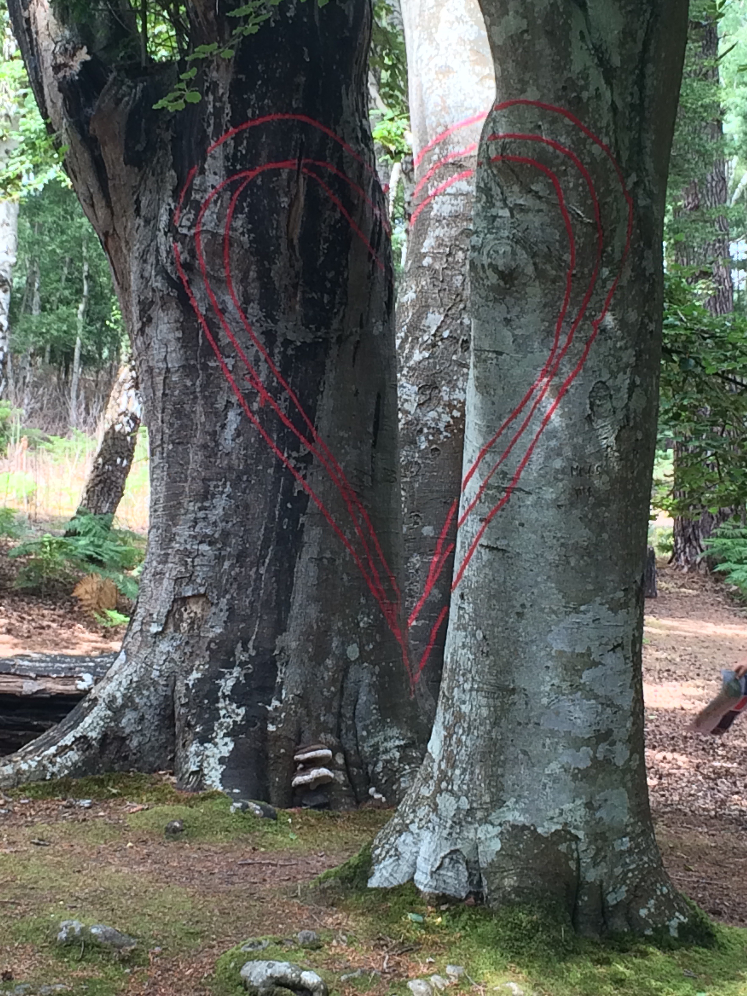
up close to a peahen and her peachickWe walked back to the jetty via some cool art work in the woods. Red lines had been painted on trees so that if you stood in the right spot the lines all matched up to make a heart. Very clever.
a red heart……and another……and anotherBack at Sandbanks we walked along the beach to the car park, where I collected my rucksack and we said goodbye. It had been a relaxing morning.
looking back along Sandbanks’ beach towards Brownsea IslandI carried on along the promenade that runs right through Bournemouth. There were plenty of people enjoying the sunshine, on the beach and sat outside the many, many beach huts that line the promenade.
it’s a long promenade around BournemouthI had fantastic views across Poole Bay, from Old Harry to the West to The Needles and the Isle of Wight to the East.
Is that the Isle of Wight?i think the volume of sand has increased further along the promenade!There was an RAF Hercules circling around the Bay for ages. Twice I saw it drop things into the water, including at least one boat. Must have been the SBS practising. Whatever, I was surprised by just how many people take binoculars to the beach!
a Hercules flying over Old HarryBehind the promenade, the cliffs are quite high and there are a couple of cliff lifts for those who don’t want to climb the zig zag pathways to the top. Naturally I caught a lift.
travelling up East Cliff LiftI made my way to Kath’s house, not far from the Stour Valley. Kath’s friend, Suzy, joined us for the evening and we all walked to The Pie House in Tuckton for pie and mash. Delicious.
looking back along Bournemouth seafrontlooking ahead to Hengistbury Head and the Isle of Wight
It had been a cold night; the first one for several weeks where I had to zip my sleeping bag right up. That meant the tent was soaking wet in the morning but it didn’t take long to dry. Getting up early meant I avoided the queues for the portaloos, which was a good start.
Time for a cup of tea and a bacon and egg bap while I waited for my tent to dry and the mist to lift. I was looking forward to seeing friends, washing my clothes, a bed and finishing the SW Coast Path. For some reason finishing this path feels like a big achievement. Perhaps it’s because I met so many people doing bits of it on the way around?
St Aldhelm’s ChapelI set off for St Aldhelm’s Head, which has a funny little 800 year-old chapel near the Lookout Station. It was a beautiful spot and there was a strong tidal race. I popped into the Lookout Station to get a weather forecast: sunshine and showers.
a memorial to secret radar research carried out at Worth MatraversThere was a WW2 memorial to vital radar research that was secretly conducted here 1940-42.
the view back along the coast of the Lulworth RangesIt was a lovely walk along the cliffs to Anvil Point and Durlston Head.
lots of caves hollowed out of the Isle of Purbeck rockstrip lynchets (caused by ploughing) visible on the hillsidesThe cliffs here often have flat ledges and there was one in particular I was looking for: Dancing Ledge. I had been here before and there was a small tidal pool hewn out of the rock. These cliffs are a favourite place for coasteering and, sure enough, Dancing Ledge had lots of people about, which always puts me off going for a dip. The tide was high anyway and the pool half covered by the sea. It is a lovely place.
Dancing Ledge; the tidal pool just about uncoveredThere are lots of sea-side caves on these cliffs and, just before Dancing Ledge, I had passed Winspit and Seacombe. Both were small, stream-filled valleys and there were a couple of tents pitched on the cliff ledges. I supposed the occupants had been to the Square and Compass last night and were free camping for the sheer hell of it (wilfully ignoring the ‘no camping’ signs).
wild campers at WinspitI rounded Anvil Point, past the lighthouse, and into Durlston Country Park. It is a shame you can no longer go in the Tilly Whim Caves; old limestone quarries dug into the Durlston cliffs. They looked impressive. sea kayakers around Anvil Point
the lighthouse at Anvil Point
Also impressive, and odd, was the large globe that had been given a position of importance, just below the small and silly-looking Durlston Castle.
The Large Globe at Durlston HeadThere was another strong tidal race at Durlston Head and the path turned North, curving around Durlston Bay, to Peveril Point and Swanage.
Peveril Point, and Old Harry behindSwanage was packed with people and I was hungry. I found a fairly empty Italian restaurant and stopped for a very nice pizza and coffee. I was due to meet Andrea at 1pm to walk the next part so I made the most of my break.
Swanage viewed from Peveril PointSwanage Pier and Bay, heading around to Old HarryI found Andrea, dumped my bag in Steve’s car, and we set off around Swanage Bay. It was great to catch up with Andy after a long time, even if she did bring the rain with her (there was a slight drizzle going on but not enough to need waterproofs – anyway mine were now in Steve’s car!).
looking back on Swanage and Peveril PointWe had lots to chat about as we headed out of Swanage and climbed up Ballard Down.
Poole Harbour just visible through the gloom from Ballard DownWe met Karen, Andrea’s mum, at the top of the Down and the 3 of us walked to Old Harry, at the Foreland Point. From here we should have had commanding views of Poole Harbour and Poole Bay, but unfortunately the mizzle put paid to that. Old Harry’s Rocks looked good though.
Old Harry’s RocksWe walked down into Studland. Studland beach was another site of D-Day practice. This one had the distinction of having Fort Henry observation post built by the Canadians so that Churchill et al could watch the live firing practice in relative safety. This was also where the amphibious tanks were tested; they were not successful as 27 of 29 sank off Omaha Beach.
Observing Studland Beach from Fort HenryThe tide was in and Studland Beach had been reduced to a thin line of sand, every bit of which was filled with people. Andrea and Steve have a beach hut so we met up with the rest of the family and there was time for tea and biscuits.
lookig back at Old Harry from StudlandAt the end of the afternoon Steve, Max, Amelie and I set off along the beach, walking the last 2 miles of the SW Coast Path to South Haven Point. It was nice to have company for the last section. I was amazed how pleased I felt at completing this particular path; it had been my favourite long walk. We reached the small entrance to Poole Harbour, opposite Sandbanks, and posed for photos next to the signs. I was quite elated at my achievement.
Me, Max and Amelie made it to South HavenThis time I didn’t need to catch the ferry as Andrea picked us up in the car and we went home for a celebration BBQ. It had been a lovely day.
It was very windy during the night and I was glad that I was tucked behind a big hedge. It was a fairly dull start to the day but that didn’t last long and soon the sun was bright, the sky was blue and it was another scorcher. Unfortunately the wind died down so that made it feel hotter.
looking across The Fleet to Chesil BankIt was lovely walking through the Fleet Lagoon Nature Reserve, with great views of Chesil Bank. I was struck by the large numbers of butterflies, of several species; more than I had noticed elsewhere.
Chesil BankChesil Beach is one of the finest storm beaches in the world; formed over 6000 years ago by rising sea levels. It is 18 miles long, rises up to 15m high in places, and is made up of 100 million tonnes of pebbles. It is amazing to walk alongside (it would be energy-sapping to walk along it) and to see how it changes. The pebbles grow in size from pea-sized in the West to potato-sized in the East. Apparently, on a foggy day, local fishermen (and smugglers) can tell whereabouts they are on Chesil Beach just by the size of the stones.
Chesil Bank is quite big in placesI walked past a couple of Army camps on the edge of Weymouth and found out later that the town had been the main base for Anzac troops convalescing during WW1.
another view of The Fleet and Chesil BankAfter an exposed walk in the heat, with no refreshment stops, I made it to Wyke Regis and Ferrybridge, the tip of Weymouth. I was hungry.
Chesil Beach curving around to the Isle of PortlandI crossed the road heading across the tombolo to the Isle of Portland, that would be tomorrow’s walk. Instead I turned North East and walked along the edge of Portland Harbour towards Weymouth sea front.
a plaque on the housing estate is the only reminder this was once the site of a torpedo factoryRight at the tip was a housing estate built on the site of the demolished Whitehead’s Torpedo Factory. Torpedoes were built here, and tested in the harbour, between 1891 and 1969.
looking down one of the breakwaters that creates Portland HarbourPortland Harbour was a Victorian engineering project that took 23 years to complete by 1872. Back then it was one of the largest man-made harbours in the world and Europe’s finest deep-water port. Naturally it needed protecting and so 3 forts were built: one in Weymouth (Nothe Fort), one on Portland, and one on the Breakwater. These forts were part of the 74 Lord Palmerston forts built all along the South coast, from Milford Haven to Harwich, to protect us against the threat of a French invasion. (Every day more jigsaw pieces are added to the picture in my head.)
the view from Nothe Fort, protecting Portland HarbourI thought the harbour looked impressive. I stopped for an ice cream at Sandsfoot Castle, built under the orders of King Henry VIII to protect shipping in the ‘Portland Roads’. Thus confirming that Portland Harbour has been important for a long time.
Sandsfoot Castle ruinsI was still hungry. I saw a sign for a cafe at Nothe Castle (rhymes with clothe) and made a beeline. After some refreshment I took the opportunity to look around the fort and I’m glad I did. It had some excellent displays and was a great little museum. Being a fort, it was of course well placed to afford some of the best views. How lucky that the sky had turned so blue to make the views all the way from the Isle of Portland to the Isle of Purbeck even more spectacular. I stayed for a while to enjoy them.
inside Nothe Fortlooking at Weymouth from Nothe FortI like to catch a ferry and there was a rowing boat ferry across the River Wey from Nothe Fort Gardens to the old harbour. I hadn’t been ferried by a rowing boat since Suffolk! This one cost me £1.
my ferry across the River WeyThe summer holidays had started; Weymouth Beach was packed. There were people everywhere, many burning in the hot sun. The green sea looked cooling but I couldn’t face the crowds so I carried on walking along the promenade, dodging the tourists.
Weymouth BeachI was intrigued to see the Royal Navy holding a beach rugby tournament; a good way to draw in spectators.
Weymouth is known for its sand sculptures – apparently it’s the right kind of sand!King George III spent 14 summers in Weymouth, helping to establish it as a holiday destination from the late 18th Century. The town’s affection for the King was evident. I admired his bathing machine sat in the middle of a roundabout.
a bathing hut fit for a KingI had arranged to meet up with my next-door-neighbour, Grace, as she often works in Weymouth. So, once I reached Lodmoor Country Park, I turned around and walked back along the promenade to the harbour and the Ship Inn.
the beautiful white cliffs of White Nothe (and all along to Lulworth) visible from Weymouth Beachlooking back along Weymouth Beach to Nothe Fort and PortlandAfter a lovely catch-up with Grace (and the chance to rid myself of a few old maps) I was collected by Geoff and driven to his house in Dorchester. It was great to see Geoff and Kath, enjoy a BBQ, do my laundry and sleep in a bed.
Weymouth Harbourtypical Weymouth seafront houses, all decked in bunting
the view from Berry Head, all the way back to Start PointFor the first time in at least a week I woke up and my tent was dry. Typical then that I should prepare to set off early and, just as I came out of the toilet block, it rained. It was only a short shower, but enough to delay me 45 minutes while I dried my tent.
walking out to Berry HeadIt was nice to walk around Berry Head, the Southern end of Tor Bay, with good visibility. This headland is now a country park, complete with ruins of a Napoleonic Fort. The iron ore and ochre found in these limestone cliffs was used to develop the first rust-resistant paint, another string to Brixham’s bow.
the view across Tor Bay from Berry HeadRounding Berry Head I got an incredible view all around Tor Bay. The red sandstone cliffs really stand out, amongst the amorphous mass of buildings. The English Riviera really is quite crowded.
Paignton and suburbsI passed through Brixham Harbour, Elberry Cove, and on to Broadsands, the first of the main beaches (Goodrington Sands, Paignton and Torquay being the others).
Brixton Lidoprocessing seafood at Brixton HarbourI liked that Brixham had lots of small gardens that were being tended by volunteers who worked under the strap line “Pride in Brixham”. The town also keeps a “heritage fleet” of old fishing sail ships running for groups and young people to experience sailing.
one of Brixham’s lovely gardens around the harbourBrixham’s Heritage FleetApproaching Broadsands I could hear a steam train, and then I saw it, the Paignton and Dartmouth Steam Railway. In the sunshine, walking along The English Riviera, which has a certain style and air, I felt like I’d been transported back to a 1930s Agatha Christie novel. I’m pretty sure I saw Poiriot in the train window – he must have been heading to the Burgh Island Hotel to investigate a murder!
Elberry Covethe steam train on the line above BroadsandsAfter all the beautiful, golden, sandy beaches I’ve passed, it was strange to see the ochre-red colour of these beaches. The sea also looked different, no longer clear, but opaque. The setting was stunning. On this hot day there were plenty of people enjoying the beach and the sea.
a beautiful view of BroadsandsI assumed that because Tor Bay is a very deep bay it is therefore sheltered and the sea generally calm. I came to this conclusion because none of the beaches had lifeguards, instead they had “beach managers”.
Goodrington Sands (next to the railway line)beach huts on Goodrington Sands, below Roundham HeadTor Bay really is a holiday Mecca. There was a huge water park and plenty of amusements and shops. Paignton had all the fun of Blackpool, but with more consistent sunshine and warmth. When I reached Paignton I veered off the wide, grassy promenade and walked up the main tourist street into town, heading for the Victorian Times tea shop.
looking back at Berry HeadPaignton’s painted houses on the sea frontGary and Deb, friends who own the tea shop, were expecting me for lunch. I was delighted to be treated to proper tea, in a teapot, and some delicious homemade food. I had a 2-hour break and could have stayed longer.
a proper pot of tea at Victorian TimesIt was still hot and sunny when I left Gary and Deb (with another cake for later) and headed around to Torquay.
approaching TorquayThe marina had several expensive-looking boats in it and the old town behind it reeked of faded gentility. The Pavilion was boarded up and crumbling, a bit like some of the enormous old houses on the cliff. Newer additions to the town looked to be a big wheel (smaller than the London Eye but same concept) and a place called Living Coasts, which is a zoo of sorts and covered by huge netting.
Torquay Harbour (the Living Coasts netting clearly visible)TorquayHolly kindly came and picked me up from Kilmorie, almost at the far end of Tor Bay.
approaching Kilmorie, the North end of Tor BayIt had been a beautiful, slightly surreal, and very hot walk around the whole of the bay, the heart of The English Riviera. looking across the entirety of Tor Bay, from the North to Berry Head
Camping at Jonny and Jane’s farm, near Talland Bay
Sunshine and warmth woke me up, but that soon disappeared once I had packed away.
looking along to Pencarrow Head and beyondIt was a nice walk along the cliffs, albeit everyone I met warned me the route to Polperro was very up and down. Lantic Beach was particularly stunning. In fact there were several places where it might be nice to go for a swim either off a beach or some rocks. Lantic Bay
Lantic Bay and Pencarrow Head
The cliffs were thick with ferns and greenery, and the path did indeed go up and down. I was surprised to see a small house tucked in the bushes about two thirds of the way down the cliff overlooking Lantivet Bay. I couldn’t resist descending a steep path to investigate. It must be somebody’s holiday cottage; the only way to it was via steep paths, either walking the cliffs or up from a boat.
a cottage hiding in the ferns on the cliffI met a Cornish fisherman on the rocks. He was fishing for Bass but apparently the water was too “gin clear” and calm for Bass fishing today.
“gin clear” water and space to land a boat to reach that cottageI also met an old man who must have been in his eighties. He had done a short circular cliff walk and finished off with a swim from one of the small coves. What a great start to his day.
a small cove at West CoombeThere wasn’t much wind so it was another sweaty walk, compensated by great views.
beautiful cliffs and rocks with streaks of whiteI reached Polperro around lunchtime and it was very busy. It was the last day of their festival week and a band was tuning up on the small stage. This typical fishing village had buildings crammed in everywhere so it was amazing they found a space big enough for a stage.
approaching Polperro, tucked away (Chapel Pool should be at the base of these rocks)Unfortunately the tide was in so the Chapel Tidal Pool wasn’t visible at the base of the rocks. Instead I popped into one of the pop-up art galleries for the festival but I didn’t fancy bothering with the model village.
PolperroThere were lots of cafes and I was very hungry so I popped into one to get a fish finger sandwich and escape the rain that was coming in. By the time I left there was a thick sea mist and it was drizzling. Such a quick change in the weather.
Polperro, stretching up the valleyIt was a short walk around To Talland Bay, which had a lovely looking beach cafe, with beach huts to sit in to shelter from the weather. There was a big hill to walk up to get to Jonny and Jane’s. Jonny kindly collected me in his landrover. Talland Bay is down there, in the mistI had a great afternoon and evening. We drove to East Looe for coffee and cake and then Jane made an excellent curry for dinner. I camped on their farmland, next to the yurt that they were sleeping in. Jane is a food writer, recipe creator and photographer. I got some tips on cafes for the next stretch. She’s got a much better blog than mine http://www.hedgecombers.com.
Coverack’s harbourIt was still raining when I left the youth hostel but it was easing. Still, it was a wet and slippery walk over rocks, through mud and undergrowth as I made my way to Lowland Point. I had to negotiate not only the terrain but also find a way past the cows and ponies.
looking back towards Coverack from Lowland PointJust around the point I found myself along a section with small towns and Gabbro rock quarries. As a consequence the path weaved inland around Manacle Point, near The Manacles, the cause of too many shipwrecks.
Dean QuarryGodrevy Cove and “Shark’s Fin” rock at Manacle PointThere was a very steep road descent into, and ascent out of, Porthoustock. A tiny village tucked in the hillside.
PorthoustockAs I walked along the tiny country roads it began to dry up a little, although it remained damp and very muggy. I saw a sign for Fat Apples Cafe so thought I ought to investigate and dry out a bit over a coffee. The owner took pity on my soggy state and gave me an extra large slice of cake.
Porthallow beachIt was only a short walk down the hill into Porthallow. I was surprised to find a marker highlighting this town as the official mid-point of the SW Coast Path.
6 weeks to get halfway (was supposed to take 4 but I kept stopping)Rounding Nare Point all of a sudden the Helford River and the coast around Falmouth Bay came into view. There were boats everywhere, particularly sail boats.
walking to Nare PointI stopped at the Coast Watch Station on Nare Point. There were 8 big tankers visible, all ‘bunkering’ between Falmouth and Lizard. Apparently lots will remain at anchor for a while, awaiting orders.
Nare Point Coast WatchDuring WW2, Nare Point was transformed into a “fake Falmouth” by Ealing Film Studios. I couldn’t see any obvious bomb craters so I don’t know whether it worked or not.
a small cove around Gillan HarbourI made it to Gillan Harbour an hour after low tide and just about got across the stepping stones, which were mostly at water level and very sloppy. It saved a 2 mile walk around the roads, or alternatively a paddle. slippery stepping stones across Gillan Harbour at low tideSt Anthony-in-Meneage seemed like it might be the first of many quaint little ‘boaty’ villages. There was a nice walk around Dennis Head, with great views on the right day.
St Anthony-in-Meneagelooking back up the creek at GillanHelford was incredibly picturesque. There seem to be quite a lot of thatched cottages on this side of Cornwall, and Helford was no exception. Such a beautiful village means lots of tourists.
HelfordHelfordI popped into the excellent village stores and bought a delicious homemade flapjack, then walked to the quayside and opened the wooden sign that signals the ferry boatman.
the Helford River ferry arriving to pick me upOverhead views of the Helford River look rather spectacular, but I had no intention of walking around every creek in South Cornwall. I like ferries.
lookin across Gillan Harbour from Dennis HeadAs there was no accommodation anywhere nearby I had already decided the best option was to catch the bus to Falmouth. Here I was invited to stay with Wendy and Brian. Luckily for me they were happy to put up with me for 2 nights.
a lovely little beach just before HelfordUnfortunately I had misread the bus timetable and thought there was a 3.15 bus to Falmouth, I missed the small print that this bus only runs in school holidays. So, I alighted the ferry at Helford Passage, walked straight past The Ferryboat Inn (which I’m told is really nice) and bust a gut to get up a very steep hill in double quick time. It was only when I was sweating at the top that I realised my error and had to wait 1 hour 15 minutes for the next bus. I wished I’d spent that spare time in the pub!
approaching Helford, so many boats!the view across the Helford River to Helford PassageI had a lovely evening with Wendy and Brian, and got to wash all my kit. Bliss. a beautiful campsite right by St Anthony-in-Meneage
It was a beautiful, sunny day with a clear blue sky; however, it was very windy.
Gwithian beach and Godrevy IslandI had always intended to take a day off at Gwithian because I needed to be around St Ives on Thursday. Jill very kindly offered to host me for a second night (at least I think she did and hopefully it wasn’t that I just didn’t leave!).
I spent a lovely morning chatting over tea and coffee, and checking out the CCTV that Jill has in her bird box. We were watching 6 very noisy Great Tit chicks being fed and getting ready to fledge.
Gwithian Methodist Chapel, built in 1810, with a thatched roof, and restored by Jill’s friendJill had some things to do and my friends Gareth and Helen were in the area so I walked down to Godrevy Head to meet them. I spent the afternoon on the headland, in the beach cafe and on the beach. I rather enjoyed digging a police boat, robber’s boat and police car for Matthew and Louise. I’m not convinced any of them were as good as the ones that were dug for me all those years ago!
Matthew driving my police car!I returned to Jill’s late afternoon and we had supper and a good chinwag. She has a fascinating family. It had been a lovely, relaxing day.
Gail cooked me breakfast and made me some sandwiches, and Gerry dropped me off at St Agnes’ Head. I had been so well looked after; proper Cornish hospitality.
happy to be at St Agnes’ HeadThe sun was shining and the sky was blue, no sign of yesterday’s fog. I was lucky because today was a particularly beautiful walk. I started near the old coastguard lookout station which, on a clear day, has a 30-mile panoramic seascape from Trevose Head to St Ives. This was the place where signal fires would be lit to warn of imminent seaborne invasion.
the lookout station at St Agnes’ HeadI was in the heart of tin mining country and almost immediately passed Wheal Coates Tin Mine. It was in operation, on and off, between 1872 and 1914; however, the area had been mined for ore since the Middle Ages, first for copper and then tin.
Wheal Coates Tin MineThe mine, and the Towanroath mineshaft, looked were in striking locations on the cliff. There was a group of young artists drawing the mineshaft in the morning light.
Towanroath mineshaftIt didn’t take me long to reach Chapel Porth so I didn’t need an ice cream; however, I felt compelled to try an iced hedgehog. This was Cornish ice cream smothered in clotted cream and covered in roasted hazelnuts. Delicious…and very few calories!
enjoying an iced hedgehog!Chapel Porth is named after a mediaeval chapel and a holy well. Apparently the beach cave below the chapel was a ‘bottomless pit’ which the mythic giant, Bolster, was commanded to fill with his blood in order to prove his love for St Agnes. The rocks are still stained red.
Chapel PorthAs the tide was in I couldn’t see the cave or the rocks. Instead, I noticed that Chapel Porth is the location for the annual World belly boarding championships (no fibreglass boards or wetsuits allowed). I thought I might have to return in September to enter the event. I have a wooden belly board at home, made and painted by my dad to fit an undersized 10-year old girl. I thought I saw my dad in the photo on the board!
which one’s my dad?The next beach along was Porth Towan, although I didn’t stop. It was hot and sweaty walking up and down the cliffs to each beach.
Porth TowanThere wasn’t much breeze to keep me cool and I wore my hat all day to ward off a sunburnt head.
looking back at the tin mine and St Agnes’ HeadNancekuke Airfield, with Portreath Remote Radar Head, stands high on the cliff between Porth Towan and Portreath. As I walked down into Portreath I passed lots of large, new houses on the cliff and there were plenty more being built.
Portreath beach and harbour (kids jumping off the harbour wall)In the early 19th Century Portreath was the copper capital of the world; now it is just a small town at the Western end of the Cornish coast-to-coast path, with a popular beach renowned for body boarding.
Portreath beachOnce again the views along the cliffs were stunning and the water below looked incredibly clear and beautiful shades of blue.
look how clear the sea is!It was an easy walk along a wide path to Godrevy Head; a popular walk with several car parks along the way.
walking to Godrevy Headthe view back towards St Agnes’ HeadAlthough I was hot, the wind was picking up a bit and it was late afternoon so I didn’t fancy scrambling down the steep cliff for a swim in Fishing Cove. Besides, I wouldn’t have had it to myself.
Fishing Cove nestled at the base of the cliffThere were only 3 seals lolling around in Mutton Cove, a favourite hauling-out beach for one colony.
looking across Godrevy Head to Gwithian beachI walked around Navax Point and Godrevy Point, admiring Godrevy Lighthouse on its island off the Point.
Godrevy Island and LighthouseI might apply for the job of gardener at Godrevy LighthouseThe car parks were full and there were lots of people on the beach at Gwithian, although it’s so big that there was still plenty of room. I didn’t need to walk along the beach but cut back through the dunes and St Gothian Sands local nature reserve (created in 2005 on the site of an old area of sand and gravel extraction) to the village.
Gwithian beachI had been invited to call in on Jill when I arrived at Gwithian and so I stopped by hoping for a cup of tea. Well, one cup led to another, and then dinner and a bed for the night (which became 2 nights). Good company and a comfortable bed beat camping!


